
| Reference: | 4828 |
| Author | Andrè Thevet |
| Year: | 1575 |
| Zone: | The four continents |
| Printed: | Paris |
| Measures: | 460 x 355 mm |
| Reference: | 4828 |
| Author | Andrè Thevet |
| Year: | 1575 |
| Zone: | The four continents |
| Printed: | Paris |
| Measures: | 460 x 355 mm |
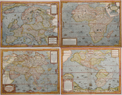
Set of the 4 continents.
Woodcuts, 1575, finely hand colored at the time, printed on contemporary laid paper, complete the marginal line, in excellent condition.
The maps are from the first edition of The Cosmographie universelle d'Andre Thevet, Cosmographe du roy: ILLUSTREE de diverses figures des choses plus remarquables veues par l'auteur, & incogneues de noz anciens & modernes, curated by Pierre the Huilier, which of one or two years before the reissue of Guillaume Chaudiere.
Born around 1516 in Angoulême, Thevet became a Franciscan friar about 1550 and made his first expedition, when he accompanied the Cardinal Jean de Lorraine in Italy and in the Mediterranean basin. Soon after, he published the Cosmographie de Levant, a compendium of facts about people, places, flora and fauna of the area visited. The experience of Thevet as a traveler came to the attention of Nicolas Durand, Knight Villegagnon, who was preparing to establish a colony in what is today Brazil. Durant asked Thevet to accompany the expedition as his confessor. During the trip, Thevet became ill and was forced to return to France after having spent only ten weeks in Brazil. However, by combining his observations with information obtained from other travelers, Thevet realized his Singularitez Antarctique de la France, published in Paris in 1557, which earned him recognition and real cosmographer the appointment of the Valois court. He then devoted himself to his most ambitious work, The Cosmographie universelle, a kind of description of each of the known world. His collaborator François de Belleforest, probably as a result of a quarrel, left him by publishing its own cosmography in 1572. Thevet’s work, of over 2,000 pages, appeared 3 years later, in 1575. Thevet continued to write real and imaginary travel until his death in 1592, leaving two manuscripts: Great Insulaire, an almanac of islands around the world, and the Histoire de deux voyages, a quick, probably amplified, of his travels in the New World.
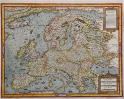
Europe
Example in the only known state. The map comes from the wall map of the world by Gerard Mercator of 1569. The map is richly ornamented with numerous sea monsters and ships, and also reports the mythical islands of Frislandia, Ibira and Enoem. Greenland and Iceland are very elongated, while Scandinavia does not differ in form from the map of Olaus Magnus.
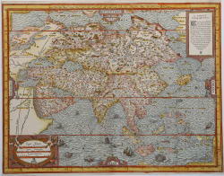
Asie
Example in the first state of two, before the address of Chaudiere and the date 1581. The map of Asia is based on the model by Mercator wall map of the world. 1569. The New Guinea strangely does not appear in the map, while Japan takes a curious form a turtle. The most important novelty of the cartographic map is represented by the correct representation of the Strait of Ananias, Bering today.
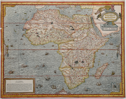
Table d'Afrique
Example in the first state of two, before the address of Chaudiere and the date 1581. Betz points out this map of Africa is an important step in the history of cartography of the continent, this is the first map of folio format to describe the area based on the Mercator’s model of 1569, by fusing the information obtained from the maps by Gastaldi and Ortelius. The result is a map that provides a huge number of cartographic information, sometimes difficult to read.
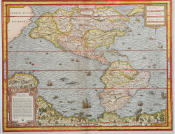
Fourth Partie du Monde
Example in the first state of three, with the typographical mark under the description in the title, published in the first edition of The Comosgraphie Universelle of 1575. Burden notes that the second state of the map does not present this mark, while the third state is with the address of Chaudiere and the date 1581. From the cartographic point of view, the map is derived from the map of the world of Gerard Mercator of 1569, while the nomenclature and morphology of the northern part seem to be the assembly of several cartographic sources. New Guinea, and a large mass southern called "Cercle Antartique" are richly decorated with scenes of native life. Excellent examples of these rare maps, among the best examples of cartography woodcut.
|
Betz, The Mapping of Africa, pp. 133/34, 17 I/II; Norwich 12; Burden, The Mapping of North America, pp.59/60, 46 I/III; Sweet, Mapping the continent of Asia, 6, I/II.
|
Andrè Thevet (Angoulême 1516 ca. - Parigi 1592)
|
Born in Angoulême around 1516, Thevet became a Franciscan friar and his first excursion into the world occurred in about 1550, when he accompanied the Cardinal Jean de Lorraine on travels into Italy and the Mediterranean basin. Afterwards, Thevet published his Cosmographie de Levant, a compendium of facts about the people, places, flora and fauna of the area. Thevet's experience as a traveler attracted the attention of Nicolas Durand, Chevalier de Villegagnon, who was preparing to found a colony in what is today Brazil. He asked Thevet to accompany the expedition as its confessor. Thevet fell ill during the voyage and had to return to France after only ten weeks in Brazil. Using his own observations, however, combined with information gained from other travelers, Thevet produced his Singularitez de la France Antarctique, published in Paris in 1557, receiving royal recognition and eventually became cosmographer of the Valois court. He began his most ambitious work, the Cosmographie universelle, which described and defined every part of the known world. François de Belleforest, who wrote in praise of Thevet in the Singularitez, apparently quarreled with Thevet and left his employ, publishing his own Cosmographie, a translation of Sebastian Munster's Cosmographia, in 1572.
Thevet claimed that much of Belleforest's new material was stolen. Certainly Belleforest stole Thevet's thunder, and the 1575 publication of Thevet's 2,000-page Cosmographie was not very successful.
Thevet continued to write of travels real and imagined. He left behind two manuscripts at his death in 1592, the Grand Insulaire, an almanac of islands around the world, and the Histoire de deux voyages, a probably exaggerated account of his travels that had him visiting the New World.
|
|
Betz, The Mapping of Africa, pp. 133/34, 17 I/II; Norwich 12; Burden, The Mapping of North America, pp.59/60, 46 I/III; Sweet, Mapping the continent of Asia, 6, I/II.
|
Andrè Thevet (Angoulême 1516 ca. - Parigi 1592)
|
Born in Angoulême around 1516, Thevet became a Franciscan friar and his first excursion into the world occurred in about 1550, when he accompanied the Cardinal Jean de Lorraine on travels into Italy and the Mediterranean basin. Afterwards, Thevet published his Cosmographie de Levant, a compendium of facts about the people, places, flora and fauna of the area. Thevet's experience as a traveler attracted the attention of Nicolas Durand, Chevalier de Villegagnon, who was preparing to found a colony in what is today Brazil. He asked Thevet to accompany the expedition as its confessor. Thevet fell ill during the voyage and had to return to France after only ten weeks in Brazil. Using his own observations, however, combined with information gained from other travelers, Thevet produced his Singularitez de la France Antarctique, published in Paris in 1557, receiving royal recognition and eventually became cosmographer of the Valois court. He began his most ambitious work, the Cosmographie universelle, which described and defined every part of the known world. François de Belleforest, who wrote in praise of Thevet in the Singularitez, apparently quarreled with Thevet and left his employ, publishing his own Cosmographie, a translation of Sebastian Munster's Cosmographia, in 1572.
Thevet claimed that much of Belleforest's new material was stolen. Certainly Belleforest stole Thevet's thunder, and the 1575 publication of Thevet's 2,000-page Cosmographie was not very successful.
Thevet continued to write of travels real and imagined. He left behind two manuscripts at his death in 1592, the Grand Insulaire, an almanac of islands around the world, and the Histoire de deux voyages, a probably exaggerated account of his travels that had him visiting the New World.
|