| Reference: | S40060 |
| Author | Matteo FLORIMI |
| Year: | 1600 ca. |
| Zone: | Mantova |
| Printed: | Siene |
| Measures: | 513 x 385 mm |
| Reference: | S40060 |
| Author | Matteo FLORIMI |
| Year: | 1600 ca. |
| Zone: | Mantova |
| Printed: | Siene |
| Measures: | 513 x 385 mm |
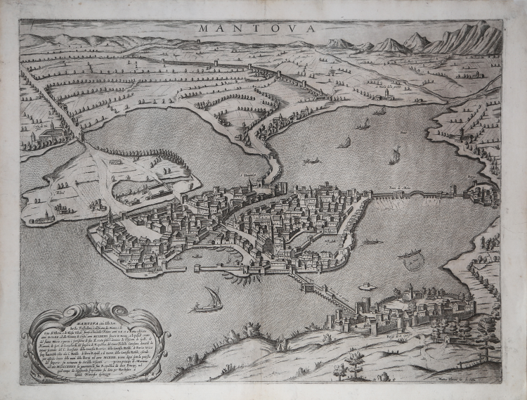
Very rare bird's eye view of the city of Mantua, signed in the plate in the lower right corner. In the cartouche, at the bottom left, the author provides historical information from the foundation of the city up to the lordship of the Gonzaga. At the top center, under the upper edge, the title is engraved: MANTOVA. In the cartouche at the bottom left we find a brief historical-geographical description: MANTOVA città della Lombardia Traspadana, è edificata da Manto e da Ocno, di Tiberio, e di Tinsia Tebani: In[n]ansi à l’incendio Troiano anni LX et a Roma edificata anni DCLXX ed alla nativita di Cristo, anni MCLXXXII situata in mezzo a le paludi create dal fiume Mincio, e perciò è fortissima di sito. È stata sotto l’dominio de Toscani, de Galli, de Romani, de Goti, de Longobardi, del Imperio, di Republica, del Conte Tedaldo, Canosano, donatali da Ottone secondo: del C. Bonifatio, della Contessa Beatrice, della Contesse Matilde, di Enrico terzo Imp. havendola tolta ala C. Matilde: di libera Republ. e di nuovo, della Contessa Matilde, essendo per assedio levata delle mani della libertà nel anno MCXIIII. Venne dipoi sotto la potesta dell’Imperio: fu occupata da Sordello Visconti…. primo prencipe di Mantova: nel an[n]o MCCCXXXII. fu governata la sua Republica da dieci Principi, nel qual tempo da Sigismondo Imperatore fu data per Marchesato à Giova[n] Francesco Gonzaga. In the lower right corner is the editorial imprint: Matteo Florimi for. In Siena.
Undated map of Mantua printed in Siena by Matteo Florimi around the end of the 16th century. It is a replica of the map inserted in the Civitates Orbis Terrarum by Georg Braun and Franz Hogenberg (Cologne 1575), of which it shows the partially Italianized toponymy. In the large and elegant cartouche on the left, historical information on the city is reported, from its foundation to 1433, when the emperor Sigismondo conferred the marquisate on Francesco Gonzaga.
The Braun Hogenberg’s model marks a fundamental stage in the evolution of printed Mantuan cartography. Abandoned the fantastic representations and notable executive ingenuity of the previous century, replaced the wooden matrices with copper ones which allow more complete results, the urban representation, even if it lacks main elements such as the castle, can be traced back to the essential layout of the city with the bridges that cross the lakes, the Rio, the island of Te, the fortified villages of Porto and S. Giorgio. The altimetric and volumetric relationships between the buildings and the road surfaces are rendered proportional; the space intended for the urban layout is in turn related to the lake. In this way the natural position of the city, in medio paludium, is immediately highlighted, which makes it exceptionally protected and defended. The representation of the elevations is dictated by a search for chiaroscuro effects and scenographic modules that respond to an aesthetic motivation, like the mountain line in the background, but this representation also responds to a criterion of hierarchical functions: in the foreground to the viewer's attention the structures of secular (the complex of the Court) and ecclesiastical (S. Pietro and S. Andrea) power. For this reason, the city was seen from the north-north-east, inaugurating a layout that would persist in many examples spun from this prototype, whose fortunes continued until the 18th century.
Etching and engraving, printed on contemporary laid paper with illegible watermark, with margins, in excellent condition.
Rare work, recorded for only 21 institutional examples in Bifolco-Ronca (cf. Cartografia e Topografia Italiana del XVI secolo, p. 2204).
Matteo Florimi (Polistena c. 1540 - Siena 1613) was a publisher and merchant of books and prints. Of Calabrian origin, he settled in Siena in 1581, with a store “in Banchi”. Matteo Florimi's chalcographic activity was several times joined by master engravers such as Cornelis Galle, Arnoldo Arnoldi, Pieter de Iode, Jan Sadeler and artists such as Francesco Vanni, Ventura Salimbeni and Alessandro Casolani, with whom the printer collaborated in the preparation of religious subjects. Florimi's cartographic activity produced prints of many cities and territories around the world, which were never drawn for him, but were manipulations of already existing reliefs, or of maps published by other printers. In the second half of the sixteenth century, Florimi was far-sighted in devoting himself to the production of bird's-eye views of cities as faithfully as possible. Florimi copied some maps by Antonio Lafreri, Claude Duchet, Abraham Ortelius. As far as map engraving work was concerned, in 1600, Matteo Florimi called the Flemish engraver Arnoldo degli Arnoldi to work in his workshop with the promise of greater compensation than that bestowed upon him by Giovanni Antonio Magini, with whom the artist was working. This offer by Florimi triggered the wrath of Magini, who, though not naming him, called him an "envious counterfeiter" for stealing such a skilled cartographer from him. The collaboration between Florimi and Arnoldi lasted only two years (1600-1602), but it was quite productive: together they printed the Stato di Siena, la Choronografia Tusciae, la Nuova descrittione della Lombardia, l’Europa, l’America and the Descrittione Universale della Terra.
Bibliografia
Bifolco-Ronca, Cartografia e Topografia Italiana del XVI secolo (2018), tav. 1124; Elisa Boffa, Un tipografo calabrese a Siena: Matteo Florimi, in “Accademia dei Rozzi” (2013): II, n. 11; H.A.M. van der Heijden, Matteo Florimi (+1613) – Landkarten und Stadtplanverleger in Siena, in “Florilegium Cartographicum”, Lipsia (1993): n. 27; Arrigoni-Bertarelli (1931): n. 789; Benevolo (1969): pp. 67-70, tav. X; Ferrari (1985): n. 12.
Matteo FLORIMI (Polistena 1540 circa - Siena 1613)
|
Print and book dealer and publisher, from Calabria. He came to Siena c.1581.Shop in Banchi. The first evidence of his independent activity is of 1589. In 1591 he published a book of patterns for lace, The Fiori di ricami, in Venice, and in 1593 a second edition in Siena.
In 1597 he published the Life of St Catherine, engraved by De Jode after Vanni, and the Passion of Christ by De Jode after Andrea Boscoli. He published a large number of maps and figural prints are mostly religious. He employed engravers of the calibre of Agostino Carracci, Cornelis Galle, Pieter de Jode Villamena and Thomassin, among others.
He commissioned drawings from Andrea Boscoli. He had a particularly close relationship with Vanni. In the years 1605-8, Florimi received financial support from Ottavio Cinuzzi.
|