
| Reference: | s7543 |
| Author | Johannes JANSSONIUS |
| Year: | 1657 ca. |
| Zone: | Mantova |
| Printed: | Leyden |
| Measures: | 490 x 355 mm |
| Reference: | s7543 |
| Author | Johannes JANSSONIUS |
| Year: | 1657 ca. |
| Zone: | Mantova |
| Printed: | Leyden |
| Measures: | 490 x 355 mm |
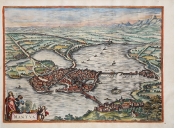
Perspective plan edited by Johannes Janssonius in about 1657. This is a faithful copy of the 1575 print by Braun and Hogenberg with variations in the position and composition of the cartouches; the original one is here replaced by the classic baroque one with figures.
Example published by Pieter Vander Aa in 1722, included in Thesaurus antiquitatum et historiarum Italiae... Lugduni Batavorum, excudit Petrus van der Aa... MDCCXXII.
"This is a very careful copy of Braun-Hogenberg's plan, the only variant being the title, here moved to the lower right and inserted in a Baroque-style composition consisting of various figures including a putto holding a compass. It is first published in the collection of Johannes Janssonius, Theatrum urbium Italiae aliarumque in insulis Maris Mediterraneae, Amsterdam s.d. (c. 1657), vol. V. Janssonius set out to renew the success enjoyed by Braun's Civitates orbis terrarum and succeeded in acquiring en bloc the collection of copperplates from the heirs of the last publisher-engraver of the work in Cologne; having eliminated the most deteriorated ones, he added several new ones, resulting in a splendid edition full of plates decorated with cartouches and frames in the Baroque style, motifs dear to the author, who understood the instances of his century and made himself its spokesman. [...] At the end of the century, Frederik de Witt, who already had to his credit editions of maps and atlases, came into possession of the branches published by Janssonius and prepared a new edition entitled Theatrum praecipuarum totius Europae urbium tam icono- graphice quam cospicue delineatarum, Amsterdam s.d. (c. 1680). The map of Mantua, which appears there, is unchanged from the Janssonius edition, only the addition, below the title, at lower left: F. de Witt excudit Amstel (odami). Finally, the plate came into the possession of publisher Pieter Vander AA, who used it to illustrate the work of Johan Georg Graevius, Thesaurus antiquitatum et historiarum Italiae, collectus cura et studioJ. G. Graevii, et ad finem perductus a P. Burmanno... Leiden, Peter van der Aa, 1704-1723; the work comprises 9 parts divided into 30 volumes; part two of tome IV is dedicated to Mantua and repeats the title: Thesaurus antiquitatum et historiarum Italiae... Lugduni Batavorum, excudit Petrus van der Aa... MDCCXXII, and contains the work, in which the perspective plan is found, titled: Baptista Sacchi cremonensis, ex vico Platina, vulgo appellati Platinae, historica inclytae urbis Mantuae et serenissimae familiae Gonzagae, in libros sex divisa" (cf. D. Ferrari, Manotva in prints, p. 53).
Bibliografia
D. Ferrari, Mantova nelle stampe, n. 27.
Johannes JANSSONIUS (1588-1664)
|
Johannes Janssonius, more commonly known to us as Jan Jansson, was born in Arnhem where his father was a bookseller and publisher (Jan Janszoon the Elder). In 1612 he married the daughter of the cartographer and publisher Jodocus Hondius, and then set up in business in Amsterdam as a book publisher. In 1616 he published his first maps of France and Italy and from then onwards he produced a very large number of maps, perhaps not quite rivalling those of the Blaeu family but running a very close second in quantity and quality. From about 1630 to 1638 he was in partnership with his brother-in-law, Henricus Hondius, issuing further editions of the Mercator/Hondius atlases to which his name was added. On the death of Henricus he took over the business, expanding the atlas still further, until eventually he published an 11-volume Atlas Major on a scale similar to Blaeu's Atlas Major.
The first full edition of Jansson's English County Maps was published in 1646 but some years earlier he issued a number of British maps in the Mercator/Hondius/Jansson series of atlases (1636-44); the maps were printed from newly engraved plates and are different from the later 1646 issue and are now rarely seen (see Appendix B for further details).
In general appearance Jansson's maps are very similar to those of Blaeu and, in fact, were often copied from them, but they tend to be more flamboyant and, some think, more decorative.
After Jansson's death his heirs published a number of maps in an Atlas Contractus in 1666 and later still many of the plates of his British maps were acquired by Pieter Schenk and Gerard Valck, who published them again in 1683 as separate maps.
|