| Reference: | S38097 |
| Author | Claudio DUCHET (Duchetti) |
| Year: | 1581 |
| Zone: | Ostia |
| Printed: | Rome |
| Measures: | 520 x 300 mm |
| Reference: | S38097 |
| Author | Claudio DUCHET (Duchetti) |
| Year: | 1581 |
| Zone: | Ostia |
| Printed: | Rome |
| Measures: | 520 x 300 mm |
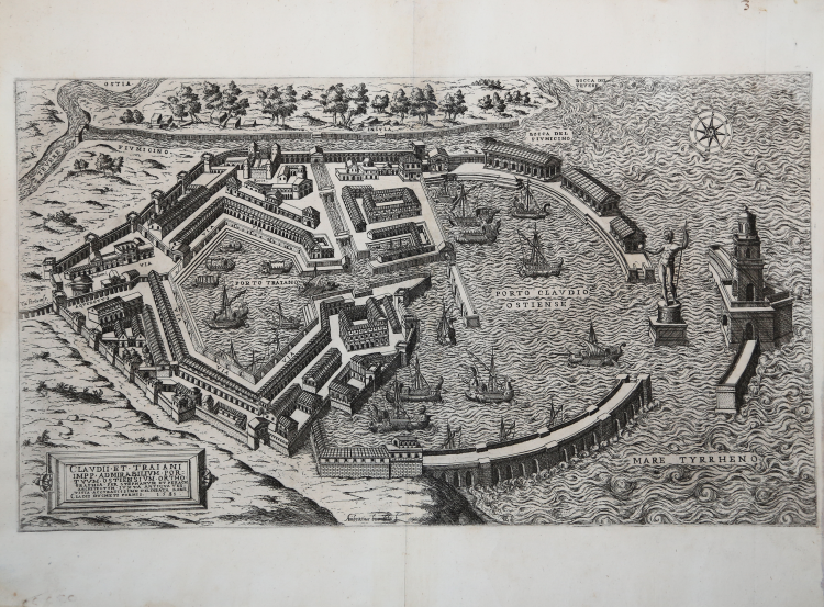
Magnificent example of the first state (of three) of the Ostia map, engraved by Ambrogio Brambilla for the publisher Claudio Duchetti.
At the bottom left, the title: CLAUDII ET TRAIANI IMPP. ADMIRABILIUM PORTUUM OSTIENSIUM ORTHOGRAPHIA PER STEPHANUM DU PERACH ARCHITECTUM IUXTA ANTIQUA VESTIGIA ACCURATISSIME DELINEATA ROME CLADII DUCHETI FORMIS 1581.
At the bottom center the signature "Ambrosius brambila f." At the top right, in the sea, a compass rose with the north-east to the left. Etching and engraving.
This map is a copy of the Duperac - Lafreri' map, engraved by Ambrogio Brambilla for the publisher Claudio Duchetti.
It is a historical reconstruction by the archaeologist Pirro Ligorio, which depicts the port wanted by Emperor Claudius, later enlarged by Trajan. The work began between 42 and 46, and it was made an open port to the west, protected by two piers. However, the continuous silting up that it underwent, led to further works that led to the construction of a further inner basin, to the east, finished under the Emperor Trajan in the year 103. The work, although topographic, is part of the Roman antiquities, aimed at making known to the general public the majesty of Roman architecture.
The Speculum (The Mirror of Roman Magnificence), found its origin in the publishing endeavors of Antonio Salamanca and Antonio Lafreri. During their Roman publishing careers, the two foreign publishers - who worked together between 1553 and 1563 - initiated the production of prints recording art works, architecture and city views related to Antique and Modern Rome. The prints could be bought individually by tourists and collectors, but were also purchased in larger groups which were often bound together in an album. In 1573, Lafreri commissioned a title page for this purpose, which is where the title 'Speculum Romanae Magnificentiae' first appears. Lafreri envisioned an ideal arrangement of the prints in 7 different categories, but during his lifetime, never appears to have offered one standard, bound set of prints. Instead, clients composed their own selection from the corpus to be bound, or collected a group of prints over time. When Lafreri died, two-third of the existing copper plates went to the Duchetti family (Claudio and Stefano), while another third was distributed among several publishers. The Duchetti appear to have standardized production, offering a more or less uniform version of the Speculum to their clients. The popularity of the prints also inspired other publishers in Rome to make copies however, and to add new prints to the corpus.
Bibliografia
Bifolco-Ronca (2018): tav. 1166, II/III; Destombes (1970): nn. 88-88a; Ganado (1994): p. 213, n. 65; Hülsen (1921): p. 147, n. 25i; Marigliani (2016): n. II.2; Pagani (2012): p. 80; cfr. Rubach (2016): n. 282; Tooley (1983): nn. 426c-426d; Witcombe (2008): p. 319, n. 5.12.
Claudio DUCHET (Duchetti) (Attivo a Roma nella seconda metà del XVI sec.))
|
Print dealer and publisher.Active in Venice 1565-1572 and Rome.He was the brother of Francesco Duchetti and a nephew of Antonio Lafrery, inheriting half his plates.
Died 5 December 1585.He was buried in San Luigi dei Francesi.By the terms of his will, his brother –in-law Giacomo Gherardi was to run the business until the majority of Claudio’s son, Claudio.
While Gherardi in charge, he was to inscribe the prints ‘haeredes Claudii Duchetti’.
He commissioned plates from among others Perret, Thomassin and Brambilla.
The name 'Lafreri-School' is a widely used, but rather inaccurate, term used to describe a loose grouping of cartographers, mapmakers, engravers and publishers working in the twin centres of Rome and Venice, from about 1544 to circa 1585. Earlier this century, George Beans, a prominent American collector of Italian maps and atlases, proposed the alternative name 'I.A.T.O.' to describe the composite collections assembled and sold by this school - 'Italian, Assembled-To-Order'. While more apposite, it has failed to catch on with modern cataloguers and collectors. For the purposes of this article, I intend to refer to the cartographers, engravers and publishers involved as "the school", although even this term implies a greater structure and organisation than can currently be established. The principal reference source on the work of the school is R.V. Tooley's Maps in Italian Atlases of the Sixteenth Century (1). In his study, published in 1939, Tooley listed some 614 maps and plates (with variant states counted separately). Some were described from personal examination, others noted from secondary sources and listings. While now much out-dated, as more recent regional carto-bibliographies have effectively superceded particular sections, and new collections have come to light, it remains the only overview of the output of the school. The principal cartographer of the school was Giacomo Gastaldi (fl. 1542-1565), a Piedmontese who worked in Venice, becoming Cosmographer to the Venetian Republic. Karrow described him as "one of the most important cartographers of the sixteenth century. He was certainly the greatest Italian mapmaker of his age..." (2). While his achievement is obvious, it is hard to quantify. A large number of maps were published throughout this period with the geography credited to Gastaldi, but it is often difficult to know what role Gastaldi played in their creation. As a practice, he did not sign himself as publisher, although his name may be found in the title, dedication, or text to the reader. Frequently where there is no imprint one may assume that Gastaldi was the publisher. A further clue may be that many of the maps attributable to Gastaldi as publisher seem to have been engraved by Fabius Licinius. In other cases, where publication is credited to another, it is not always certain whether Gastaldi was commissioned by the publisher to compile the map, whether another less-enterprising publisher merely copied his work and attribution, or simply added Gastaldi's name in the title to add authority to the delineation. His name clearly commanded the same sort of respect that the Sanson name had in the last years of the seventeenth century, and as Guillaume de l'Isle's had in the first half of the eighteenth century. Paolo Forlani was a cartographer and engraver who worked in Venice between 1560 and circa 1571. The majority of his output was published under the imprint of other publishers, such as Giovanni Francesco Camocio, Ferrando Bertelli and Bolognini Zaltieri. In a pioneering study, David Woodward (4), by identifying Forlani's engraving style through various stages of development, has attributed a large number of previously unidentified maps to his hand, and provided a clearer picture of some of the publishing arrangements of the period. In the early 1560s Giovanni Francesco Camocio published a number of maps that were drawn by Forlani, including maps of the World, North Atlantic, Africa, France, Switzerland, and provinces of the Low Countries, to note but a few. Circa 1570, Camocio published an Isolario, or collection of maps of islands, principally from the Mediterranean, but including the British Isles and Iceland. Camocio's earliest issues lacked a title-page, and tended to be a relatively random selection from the available stock. Later he added a title Isole Famose Porti, Fortezze E Terre Maritime. After his death, which is assumed to have been in 1573, the plates were reprinted, with a title-page bearing the Bertelli family address 'alla Libraria del Segno di S. Marco', possibly by Donato Bertelli, whose imprint is found on a later state of Camocio's world map of 1560. The largest grouping was the Bertelli family. The most active was Ferrando Bertelli, who flourished in the 1560's and 1570's, but maps from the last quarter of the seventeenth century are known with the imprints of Andrea, Donato, Lucca, Nicolo and Pietro. Again, a number of maps published by Ferrando were drawn or engraved by Forlani.
Antonio Salamanca (1500 – 1562) settled in Rome his chalcographical business; his activity was then carried on and enlarged by his scholar Antonio Lafrery (1512 – 1577), and then by his grand son Claudio Duchet (Duchetti), Giovanni Orlandi, Henrik van Schoel, and finally by De Rossi. In Venice, the most important centre of map production, he was initiated into engraving by Giovanni Andrea Vavassore and Matteo Pagano, who had worked with Giacomo Gastaldi, the most important European cartographer of the XVI century. Other important exponents of the Venetian chalcography were Fabio Licinio, Fernando Bertelli, Giovanni Francesco Camocio and above all of them Paolo Forlani. Although he’s better known as publisher of Roman archeology, Antoine de Lafrery, born in France, has been the publisher thathas given the biggest impulse to Roman chalcography, becoming in a few years an expert seller as well. For that reason, even though he’s not the one that has published most maps in his time, all the chalcographic works printed in Rome and Venice during the XVI century are nowadays defined as “charts of lafrerian school”. This definition was given by Adolf Erik Nordenskiold, one of the fathers of the history of cartography, who also introduced the definition of Lafrery Atlas, talking about charts printed in Rome and published by Lafrery, in which we find a sort of title page with the title Tavole moderne de geografia secondo l’ordine di Tolomeo. Lafrery’s school produced a huge amount of maps, usually selling them as separate charts and somehow and then edited in a bigger volume. Since the charts had all different measures, the artists needed to trim them with copper to get them to the same size, adding at the end estra pieces of paper, if necessary.
|