| Reference: | S11209 |
| Author | Gerard DE JODE |
| Year: | 1578 ca. |
| Zone: | Padova |
| Printed: | Antwerpen |
| Measures: | 260 x 372 mm |
| Reference: | S11209 |
| Author | Gerard DE JODE |
| Year: | 1578 ca. |
| Zone: | Padova |
| Printed: | Antwerpen |
| Measures: | 260 x 372 mm |
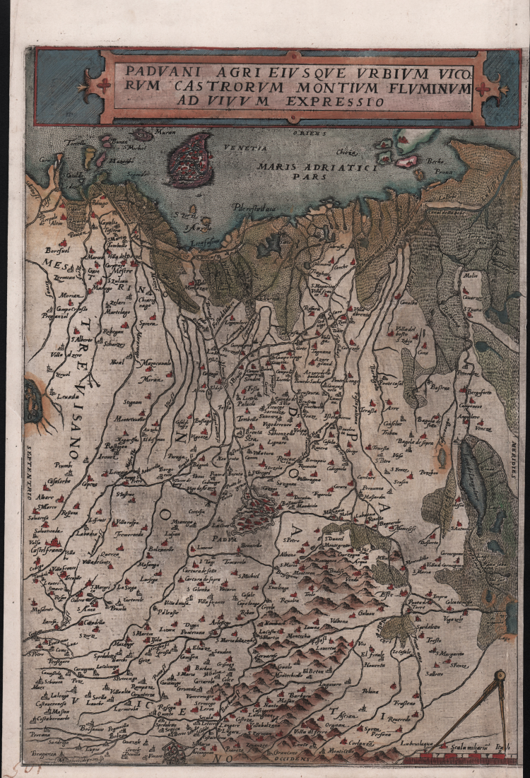
Rara carta geografica che copre il territorio dell’attuale provincia di Padova, basata sul modello do Giacomo Gastaldi, introdotto da Ferrando Bertelli e Girolamo Olgiato nel 1568. Orientata con l’est in alto, la carta si estende e si estende fino a Venezia e all’Adriatico ad est, al Polesine a sud.
La mappa è pubblicata nello Speculum Orbis Terrarum di Gerard de Jode, stampato ad Anversa nel 1578 e ristampato nel 1593 dal figlio Cornelis de Jode.
“Mappa del territorio di Padova realizzata postuma su progetto e cartografia di Giacomo Gastaldi, pubblicata da Ferrando Bertelli nel 1568. La lastra è incisa da Girolamo Olgiato a cui spesso si fa riferimento come autore di questa carta. Le città principali e i monti sono rappresentati prospetticamente, i centri minori con chiese e campanili. Un fitto tratteggio evidenzia le ampie zone paludose che caratterizzavano il territorio. In basso a sinistra, il cartiglio contiene la dedica a monsignor Giovanni Dolfin (1529-1584 italianizzato in Delfino), della nobile e potente famiglia veneta dei Dolfin, il cui stemma sormonta il cartiglio stesso” (cfr. Bifolco-Ronca, Cartografia e topografia italiana del XVI secolo, (2018) p. 1928, tav. 969).
Gerard de Jode fu un celebre incisore e stampatore, nativo di Nimega nel 1509. Dopo aver compiuto studî di matematica e di cosmografia, apprese l'arte dell'incisione, fu per qualche tempo alla corte di Carlo V a Bruxelles, poi si trasferì ad Anversa, dove già a partire dal 1551 cominciò a stampare incisioni artistiche di Franz Huys, Martin de Vos, Corneille de Cort, ecc.; ma presto si specializzò nell'incisione di carte geografiche e stampò ad Anversa il celebre mappamondo di Giacomo Gastaldi, nel 1568 l'Italia dello stesso, poi altre carte di molti autori, anche italiani, nel 1564 un grande mappamondo di Abraham Ortelius (Nova totius Terrarum Orbis iuxta neotericorum traditionem descriptio) e infine nel 1578 un vero e proprio atlante con il titolo di Speculum Orbis Terrarum, in 65 tavole, di autori diversi, già in parte pubblicate isolatamente. È uno dei primi atlanti moderni (preceduto soltanto dal Theatrum dell'Ortelius), oggi estremamente raro. Negli ultimi anni della sua vita attendeva a preparare carte dei singoli continenti, di grandi dimensioni, che forse furono poi pubblicate, al pari di un gran mappamondo, dal figlio Cornelio. Questi, nato ad Anversa nel 1568, continuò con molta sagacia l'opera del padre; nel 1589 pubblicò un mappamondo, nel 1593 una nuova edizione dello Speculum, accresciuta, in 109 carte, e nel 1596 una Introductio geographica in tabulas Europae, Asiae, Africae et Americae; le tavole, cui qui si allude, sono probabilmente quelle preparate dal padre e delle quali il figlio curò la stampa; esse non sono peraltro giunte fino a noi. Cornelio viaggiò poi a lungo nei paesi nordici e anche in Spagna. Ritornando in patria, morì a Mons il 17 ottobre 1600.
Acquaforte e bulino, finemente colorata a mano, in ottimo stato di conservazione.
Bibliografia
cfr. Bifolco-Ronca, Cartografia e topografia italiana del XVI secolo, (2018) p. 1928, tav. 969; Karrow (1993): n. 30/107; Marinelli (1881): n. 544.
|
Gerard de Jode, born in Nijmegen, was a cartographer, engraver, printer and publisher in Antwerp, issuing maps from 1555 more or less in the same period as Ortelius. He was never able to offer very serious competition to his more businesslike rival although, ironically, he published Ortelius's famous 8-sheet World Map in 1564.
His major atlas, now extremely rare, could not be published until 1578, eight years after the Theatrum, Ortelius having obtained a monopoly for that period. The enlarged re-issue by his son in 1593 is more frequently found. On the death of Cornelis, the copper plates passed to J. B. Vrients (who bought the Ortelius plates about the same time) and apparently no further issue of the atlas was published: however, at least one further issue of the Polar Map, c.1618, is known.
Son of Gerard de Jode, who was a cartographer, engraver, printer and publisher in Antwerp, issuing maps from 1555 more or less in the same period as Ortelius.
Gerard de Jode's major atlas, now extremely rare, could not be published until 1578, eight years after the Theatrum, Ortelius having obtained a monopoly for that period. The enlarged re-issue by his Cornelis in 1593 is more frequently found.
On the death of Cornelis, the copper plates passed to J. B. Vrients (who bought the Ortelius plates about the same time) and apparently no further issue of the atlas was published: however, at least one further issue of the Polar Map, c.1618, is known.
|
|
Gerard de Jode, born in Nijmegen, was a cartographer, engraver, printer and publisher in Antwerp, issuing maps from 1555 more or less in the same period as Ortelius. He was never able to offer very serious competition to his more businesslike rival although, ironically, he published Ortelius's famous 8-sheet World Map in 1564.
His major atlas, now extremely rare, could not be published until 1578, eight years after the Theatrum, Ortelius having obtained a monopoly for that period. The enlarged re-issue by his son in 1593 is more frequently found. On the death of Cornelis, the copper plates passed to J. B. Vrients (who bought the Ortelius plates about the same time) and apparently no further issue of the atlas was published: however, at least one further issue of the Polar Map, c.1618, is known.
Son of Gerard de Jode, who was a cartographer, engraver, printer and publisher in Antwerp, issuing maps from 1555 more or less in the same period as Ortelius.
Gerard de Jode's major atlas, now extremely rare, could not be published until 1578, eight years after the Theatrum, Ortelius having obtained a monopoly for that period. The enlarged re-issue by his Cornelis in 1593 is more frequently found.
On the death of Cornelis, the copper plates passed to J. B. Vrients (who bought the Ortelius plates about the same time) and apparently no further issue of the atlas was published: however, at least one further issue of the Polar Map, c.1618, is known.
|