
| Reference: | S40838 |
| Author | Johannes Baptiste VRIENTS |
| Year: | 1608 ca. |
| Zone: | Ferrara |
| Printed: | Ferrara |
| Measures: | 520 x 445 mm |
| Reference: | S40838 |
| Author | Johannes Baptiste VRIENTS |
| Year: | 1608 ca. |
| Zone: | Ferrara |
| Printed: | Ferrara |
| Measures: | 520 x 445 mm |
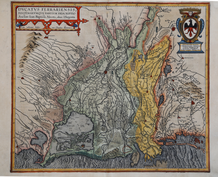
Rare early map of the Duchy of Ferrara, first published in Ortelius's Theatrum Orbis Terrarum in 1608.
This rare and handsome map centers on Ferrara, a city that became one of the great cultural centers of Italy in the 15th and 16th centuries under the reign of Ercole d'Este I, and later Alfonso II. The fertile region surrounding Ferrara is well depicted with its extensive river systems and valleys. Oriented with north to the right, the map extends to include Venice, Bologne, and the lagoons of the Valli di Comacchio. This map was based on a single sheet map of the area by Giovanni Battista Aleotti in 1603. Italian text on verso, published in 1608 and 1612with the same typesetting on verso. T
This map was among the additions made by Vrients when he took over publication of the Theatrum after Ortelius' death. It was published in relatively few editions and is very uncommon.
The Theatrum Orbis Terrarum, is considered the first true modern "Atlas". The work was published in 7 languages and 36 editions, for which - in 1570 - Ortelius obtained the privilege, a kind of copyright that prevented other cartographers from publishing his works. The Theatrum represented the most advanced work of cartographic description. Ortelius collected in it the geographical and cartographic knowledge of his time, proposing in 147 spectacular engraved plates the most faithful image of the world then known and, in some extraordinary "historical maps", regions and routes taken from literature, mythology, tradition. Ortelius was also the first to cite sources, mentioning the names of cartographers in the "catalogus auctorum". From 1598 to 1612 the posthumous editions of the Theatrum were made by his collaborator Johannes Baptiste Vrients.
Copper engraving, contemporary coloring, in good condition.
|
Van den Broecke, Ortelius, n. 133; (Koeman Atlantes Neerlandici III): 157.
|
Johannes Baptiste VRIENTS (1552 - 1612)
|
Vrients was the map engraver and publisher in Antwerp who, after the death of Ortelius in 1598, acquired the publication rights of the Theatrum. Between 1601 and 1612 he issued a number of editions which included some of his own maps and he was responsible for printing the maps for the English edition in 1606. He also published a number of important individual maps and a small atlas of the Netherlands.
|
|
Van den Broecke, Ortelius, n. 133; (Koeman Atlantes Neerlandici III): 157.
|
Johannes Baptiste VRIENTS (1552 - 1612)
|
Vrients was the map engraver and publisher in Antwerp who, after the death of Ortelius in 1598, acquired the publication rights of the Theatrum. Between 1601 and 1612 he issued a number of editions which included some of his own maps and he was responsible for printing the maps for the English edition in 1606. He also published a number of important individual maps and a small atlas of the Netherlands.
|