
| Reference: | S34870 |
| Author | Ambrogio BARUFFALDI |
| Year: | 1758 ca. |
| Zone: | Ferrara |
| Printed: | Ferrara |
| Measures: | 897 x 676 mm |
| Reference: | S34870 |
| Author | Ambrogio BARUFFALDI |
| Year: | 1758 ca. |
| Zone: | Ferrara |
| Printed: | Ferrara |
| Measures: | 897 x 676 mm |
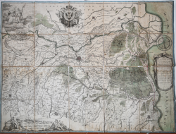
Large and important map of the Duchy of Ferrara, which also covers part of the Bologna and Modena' area, in the third and final edition, with the dedication to Francis II (1792-1806).
Third state of the map, engraved by Andrea Bolzoni was published for the first time in 1758, then in 1782 and finally in 1800.
Intersting from the hydrographic interest, the map is also interesting because for the first time the settlement and the road network of the Ferrara are highlighted.
At the end of the description, in the cartouche with the title, the editor' signature is erased.
Copper engraving, mounted on canvas, some dampstains, otherwise in good condition.
|
Alberto Alberghini, Ferrara. La storia di un territorio in una collezione di mappe e vedute dal XV al XX secolo, 2008; Angela De Vanna, La rappresentazione cartografica del territorio ferrarese: simbolismo e scientificità
|
Ambrogio BARUFFALDI(Attivo a Ferrara intorno alla metà del XVIII sec.)
|
Alberto Alberghini, Ferrara. La storia di un territorio in una collezione di mappe e vedute dal XV al XX secolo, 2008; Angela De Vanna, La rappresentazione cartografica del territorio ferrarese: simbolismo e scientificità
|
Ambrogio BARUFFALDI(Attivo a Ferrara intorno alla metà del XVIII sec.)