| Reference: | S11476 |
| Author | Girolamo RUSCELLI |
| Year: | 1561 ca. |
| Zone: | Croatia |
| Printed: | Venice |
| Measures: | 260 x 190 mm |
| Reference: | S11476 |
| Author | Girolamo RUSCELLI |
| Year: | 1561 ca. |
| Zone: | Croatia |
| Printed: | Venice |
| Measures: | 260 x 190 mm |
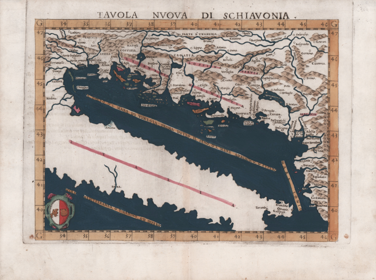
Based on the works of Claudius Ptolemy and the atlas of Giacomo Gastaldi, it focuses on the Balkans, the ‘Powder Keg of Europe’, and on many of the countries in which they form part of the landscape.
This map covers the entire length of the eastern Adriatic coast and the inland area up to the Danube in the east and the Drava in the north. The classic problems of Ptolemy's adaptations are still evident, such as the reliefs which were shown relatively arbitrarily. The river network is barely recognizable, as are the coastal land lines. The depiction of the central Dinaric Mountains from Ptolemy's template is particularly emphasized here. A number of islands in the Adriatic Sea are also shown. The seas are stippled and the map is embellished by a crest in the lower left corner, the coat of arms of Ragusa (Dubrovnik), one of the most important maritime republics of the time.
Map taken from Geographia di Claudio Tolomeo edited by Girolamo Ruscelli, published in Venice in several editions between 1561 and 1598. The maps is based on the Geografia by Giacomo Gastaldi (1548), who probably also personally drew these maps, which were engraved by the brothers Livio and Giulio Sanuto.
The peculiarity of these maps is that they are engraved two for plate and subsequently cut; this is why the copper sign only appears on three sides of the map. Ruscelli's text and his maps are considered to be the best modern atlas up to the first version of Abraham Ortelius' Theatrum Orbis Terrarum (1570).
Only their widespread diffusion prevents a sustained evaluation in the antiquarian market. In fact, the work had a first edition in 1561, printed by Vincenzo Valgrisi who also edited the 1562 reprint. There are three editions signed by Giordano Ziletti (two in 1564 and one in 1574), while in 1597 it was published by the Calignani brothers. All these editions contain 64 plates. In 1598 and 1599 the two editions edited by Giuseppe Rosaccio and printed by the heirs of Melchior Sessa came to light. These last two editions include 69 plates; in fact, Rosaccio's map of the planisphere and continents has been added.
Etching and engraving with fine later hand colour, in good condition.
Girolamo RUSCELLI (Viterbo 1504 – Venezia 1566)
|
Ruscelli was editor of a revised and expanded edition of Ptolemy’s Geographia which was issued in Venice several times between 1561 and the end of the century. The newly engraved maps were based, generally, on those compiled by Giacomo Gastaldi for the Venice edition of 1548.
|