| Reference: | S39559 |
| Author | Laurent FRIES |
| Year: | 1522 ca. |
| Zone: | East Indies |
| Printed: | Strasbourg |
| Measures: | 455 x 300 mm |
| Reference: | S39559 |
| Author | Laurent FRIES |
| Year: | 1522 ca. |
| Zone: | East Indies |
| Printed: | Strasbourg |
| Measures: | 455 x 300 mm |
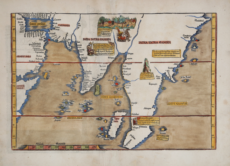
Nice example of the 1525 edition - first published in 1522 - of Fries' map of India and Southeast Asia, focusing on Southeast Asia, India, and Sri Lanka and the Indian Ocean.
The second edition is recognized by the lack of the title at the top, in a banderole cartouche; later the map was reprinted in 1535 and 1541, with the addition of a new title at the top.
Fries' map is a reduced size version of Waldeseemuller's 1513 map, the earliest modern map to focus on the region. All prior maps of the region were prepared based upon the work of Claudius Ptolemy.
Based largely upon the Ruysch world map of 1507, Sri Lanka and the Indian subcontinent are relatively correct in their sizes. This map is among the earliest documents recording the Portuguese explorations into the Indian Ocean and is of primary importance in the mapping of the India and Southeast Asia.
Various decorative embellishments are shown on the map, showing indigenous peoples and customs. Extends from Saudi Arabia to the Malay Peninsula, centered on India.
Woodcut, finely colored by hand, reconstructive restoration to the central fold perfectly executed, otherwise in excellent condition.
|
Lorenz (Laurent) Fries was born in Alsace in about 1490. He studied medicine, apparently spending time at the universities of Pavia, Piacenza, Montpellier and Vienna. After completing his medical studies, , Fries worked as a physician in several places, before settling in Strassburg, in about 1519. In Strassburg, Fries met the Strasbourg printer and publisher Johann Grüninger, an associate of the St. Die group of scholars formed by, among others, Walter Lud, Martin Ringmann and Martin Waldseemuller.From 1520 to 1525, Fries worked with Gruninger as a cartographic editor, exploiting the corpus of material that Waldseemuller had created. Fries' first venture into mapmaking was in 1520, when he executed a reduction of Martin Waldseemuller's wall-map of the World, published in 1507. Next Fries’ project was a new edition of the Geographia of Claudius Ptolemy, which was published by Johann Koberger in 1522. Fries evidently edited the maps, in most cases simply producing a reduction of the equivalent map from Waldseemuller's 1513 edition of the Geographie Opus Novissima, printed by Johann Schott. Fries also prepare three new maps for the Geographie: maps of South-East Asia and the East Indies, China and the World, but the geography of these derives from Waldseemuller's world map of 1507. The 1522 edition of Fries work , now very rare, was not commercially successful. In 1525, an improved edition was issued, from the notes of Johannes Regiomontanus. After Grüninger's death in 1531, the business was continued by his son Christoph, who seems to have sold the materials for the Ptolemy to two Lyon publishers, the brothers Melchior and Gaspar Trechsel, who published a joint edition in 1535, before Gaspar Trechsel published an edition in his own right in 1541.
|
|
Lorenz (Laurent) Fries was born in Alsace in about 1490. He studied medicine, apparently spending time at the universities of Pavia, Piacenza, Montpellier and Vienna. After completing his medical studies, , Fries worked as a physician in several places, before settling in Strassburg, in about 1519. In Strassburg, Fries met the Strasbourg printer and publisher Johann Grüninger, an associate of the St. Die group of scholars formed by, among others, Walter Lud, Martin Ringmann and Martin Waldseemuller.From 1520 to 1525, Fries worked with Gruninger as a cartographic editor, exploiting the corpus of material that Waldseemuller had created. Fries' first venture into mapmaking was in 1520, when he executed a reduction of Martin Waldseemuller's wall-map of the World, published in 1507. Next Fries’ project was a new edition of the Geographia of Claudius Ptolemy, which was published by Johann Koberger in 1522. Fries evidently edited the maps, in most cases simply producing a reduction of the equivalent map from Waldseemuller's 1513 edition of the Geographie Opus Novissima, printed by Johann Schott. Fries also prepare three new maps for the Geographie: maps of South-East Asia and the East Indies, China and the World, but the geography of these derives from Waldseemuller's world map of 1507. The 1522 edition of Fries work , now very rare, was not commercially successful. In 1525, an improved edition was issued, from the notes of Johannes Regiomontanus. After Grüninger's death in 1531, the business was continued by his son Christoph, who seems to have sold the materials for the Ptolemy to two Lyon publishers, the brothers Melchior and Gaspar Trechsel, who published a joint edition in 1535, before Gaspar Trechsel published an edition in his own right in 1541.
|