
| Reference: | s14065 |
| Author | Willem Janszoon BLAEU |
| Year: | 1630 ca. |
| Zone: | Moluccas |
| Printed: | Amsterdam |
| Measures: | 480 x 370 mm |
| Reference: | s14065 |
| Author | Willem Janszoon BLAEU |
| Year: | 1630 ca. |
| Zone: | Moluccas |
| Printed: | Amsterdam |
| Measures: | 480 x 370 mm |
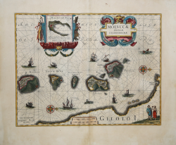
Early edition of Blaeu's important and highly decorative map of the Spice Islands.
The map features a large inset of the Island of Bachian (Batjan) in an elaborate frame as well as a Moluccan couple in the lower right corner in Europeanized native dress.
Indicative of the area's commercial importance, Blaeu has filled the seas with both European and local ships, two of which are engaged in battle. Sea monsters and decorative compass 2 roses are also shown.
This is a lovely example of an original map of the Spice Islands by Blaeu printed at the height of activity and trade by the Dutch East India Company (Vereenigde Oost Indische Compagnie, V.O.C.) in the region.
The map centers on what is known today as the "Bacan Islands" of Indonesia. In 1609 the VOC concentrated their power in the area by establishing Fort Barnaveld on Bachian Island which is depicted in the inset map at top left. Several other forts would soon follow and can be found within the map.
The wealth from trade a knowledge from exploration in the east indies made the Netherlands the wealthiest European country per capita with Amsterdam being the epicenter of concentrated wealth. This economic boom along with new information endlessly coming into port helped support the map makers such as Willem Blaeu during what is now known as the Golden Age of Dutch Cartography.
This map is embellished with sailing ships of both European and Indonesian design, sea monsters, two striking compass roses, and elaborate title cartouche, and a vignette of two natives holding a plate of food, a shield and machete while dressed in more traditional Dutch garb which was given to locals as a sign of good will before exploiting their riches.
Willem Janszoon Blaeu, started in 1599 his business as a builder of globes and astronomical instruments in Amsterdam. In 1630, after buying some plates of the Mercator atlas from Jodocus Hondius II, he was able to publish a volume of 60 maps under the title Atlantis Appendix. Five years later, he published the first two volumes of his atlas Atlas Novus or Theatrum Orbis Terrarum, in six books. After his death, Joan (Johannes) continued his father's work, completing the entire six-volume Atlas Novus series around 1655. He was also the author of an Atlas Maior sive Cosmographia Blaviana, in 12 volumes published in 1662 -72.
From the latin edition of Blaeu's Atlas Novus. Original colouring with later addition, good condition.
Willem Janszoon BLAEU (Uitgeest 1571- Amsterdam 1638)
|
At the beginning of the seventeenth century Amsterdam was becoming one of the wealthiest trading cities in Europe, the base of the Dutch East India Company and a centre of banking and diamond trades, its people noted for their intellectual skills and splendid craftsmanship.
At this propitious time in the history of the Northern Provinces, Willem Janszoon Blaeu, who was born at Alkmaar in 1571 and trained in astronomy and the sciences by Tycho Brahe, the celebrated Danish astronomer, founded a business in Amsterdam in 1599 as a globe and instrument maker.
It was not long before the business expanded, publishing maps, topographical works and books of sea charts as well as constructing globes.
His most notable early work was a map of Holland (1604), a fine World Map (1605-06) and Het Licht der Zeevaerdt (The Light of Navigation), a marine atlas, which went through many editions in different languages and under a variety of titles.
At the same time Blaeu was planning a major atlas intended to include the most up-to-date maps of the whole known world but progress on so vast a project was slow and not until he bought between 30 and 40 plates of the Mercator Atlas from Jodocus Hondius II to add to his own collection was he able to publish, in 1630, a 60-map volume with the title Atlantis Appendix.
It was another five years before the first two volumes of his planned world atlas, Atlas Novus or the Theatrum Orbis Terrarum were issued. About this time he was appointed Hydrographer to the East India Company.
In 1638 Willem Blaeu died and the business passed into the hands of his sons, Joan and Cornelis, who continued and expanded their father's ambitious plans.
After the death of Cornelis, Joan directed the work alone and the whole series of 6 volumes was eventually completed about 1655.
As soon as it was finished he began the preparation of the even larger work, the Atlas Major, which reached publication in 1662 in II volumes (later editions in 9-12 volumes) and contained nearly 6oo double-page maps and 3,000 pages of text.
This was, and indeed remains, the most magnificent work of its kind ever produced; perhaps its geographical content was not as up-to-date or as accurate as its author could have wished, but any deficiencies in that direction were more than compensated for by the fine engraving and colouring, the elaborate cartouches and pictorial and heraldic detail and especially the splendid calligraphy.
In 1672 a disastrous fire destroyed Blaeu's printing house in the Gravenstraat and a year afterwards Joan Blaeu died. The firm's surviving stocks of plates and maps were gradually dispersed, some of the plates being bought by F. de Wit and Schenk and Valck, before final closure in about 1695.
It ought to be mentioned here that there is often confusion between the elder Blaeu and his rival Jan Jansson (Johannes Janssonius). Up to about 1619 Blaeu often signed his works Guilielmus Janssonius or Willems Jans Zoon but after that time he seems to have decided on Guilielmus or G. Blaeu.
|