| Reference: | S5141 |
| Author | Giovanni Antonio MAGINI |
| Year: | 1596 |
| Zone: | Sri Lanka |
| Printed: | Venice |
| Measures: | 180 x 135 mm |
| Reference: | S5141 |
| Author | Giovanni Antonio MAGINI |
| Year: | 1596 |
| Zone: | Sri Lanka |
| Printed: | Venice |
| Measures: | 180 x 135 mm |
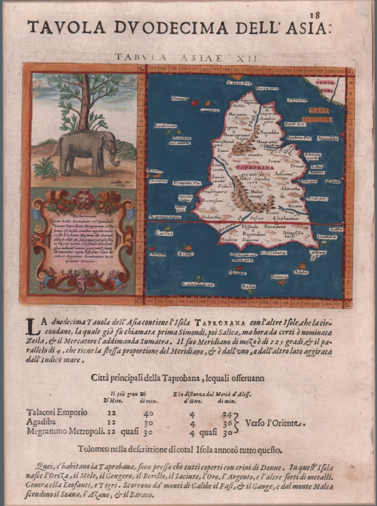
Finely colored example of Magini's map of Taprobana, the island of Ceylon, which was sometimes confused with Sumatra on early maps.
In ancient times, Sri Lanka was known by various names, Ptolemy named it Taprobana, the Arabs Serendib, the Portuguese called it Ceilo and the British Ceylon.
Situated at the centre of numerous trade routes through the Indian Ocean, Sri Lanka was always an important trading link between east and west. As a major exporter of cinnamon, Arab and Chinese traders had frequented the island since early times and it served as an important stop for merchants on the maritime route between Asia and Europe. Much confusion existed among medieval mapmakers as to the identities of the islands of Taprobana and Sumatra which arose primarily from the descriptions in the ancient texts which stated that Taprobana was the largest island in the world. This was later contradicted by Marco Polo in his Il Milione in which he stated that it was Java Minor (Sumatra) that was in fact the largest island. As Sumatra was virtually unknown to most medieval mapmakers their primary concern was the placement of Taprobana on maps. Invariably it was incorrectly positioned off the southeast coast of Arabia but once the accounts of Marco Polo were revealed at the end of the thirteenth century, the eastern limits of the Indian Ocean were greatly expanded and the question as to the identity of the islands became more critical for mapmakers.
The Portuguese arrived on the island in 1505 and by 1518 had built a fort in Colombo, enabling them to control strategic coastal areas they had previously captured. Once Portuguese information and charts were copied, the position of Ceylon and the confusion with Sumatra was corrected.
Although, some scholars believe it is actually a depiction of the island of Sumatra. The surrounding islands are located near where Nias, Enggano and Mentawis are relative to Sumatra. The land in the upper-right corner is correct for Malaysia. Several towns and village are located (close to present cities of Lampung, Medan, Sibolga and Banda Aceh. Mountains and waterways are also located - also very near where they are found today.
Map taken from the Geografia cioè descrittione universale della Terra of Claudio Tolomeo by Giovanni Antonio Magini, first printed in Venice in 1596, at the Heirs of Simon Galignani de Karera.
The Maginian collection contains 64 copper engravings finely carved by Girolamo Porro and was soon copied by Petrus Keschedt, a publisher from Cologne (the maps of the two editions are almost indistinguishable).
A subsequent reprint of Magini's work, with the translation by Leonardo Cernoti from the Latin text, was printed in Padua by the Galignani brothers in 1621. With this edition of the Geografia “the long series of editions of Ptolemy’s Geography, revised and extended as text books of modern geography, seems to have come to an end” (Stevens, 1972, p. 22).
Etching with fine later hand colour, in excellent condition.
Giovanni Antonio MAGINI (1555 - 1617)
|
Giovanni Antonio Magini was born in Padua in 1555, dedicating himself to the study of astronomy from an early age. In 1588 the Senate of Bologna appointed him Lecturer of Astronomy at the local University, choosing him instead of Galileo Galilei. His friendship with the Duke of Mantua, Vincenzo Gonzaga, helped Magini in his quest to obtain cartographical material for map-making from the various sovereigns ruling the different Italian states at that time. Because of Magini's early death in 1617, this effort was made famous by his son Fabio when he published the atlas "L'Italia" in Bologna in 1620. This is the first example of an Italian atlas and is made up of 24 pages of descriptive text and 61 maps of the Italian peninsula. Although this work was published posthumously, it can be entirely ascribed to Magini. He began drawing this maps around 1594, with the one depicting Bologna and its surrounding territories being the first. They were all printed before 1620 in draft editions which were then revised and updated for the final version. These draft proofs are extremely rare, although sometimes available for sale, and exhibit substantial differences in respect to the maps finally included in the atlas. Two of the most famous engravers of the time, Arnoldo Arnoldi and the englishman Benjamin Wright, were entrusted by Magini to engrave the plates. As we shall see in the presentation of the separate maps, they derive from different sources, both known and unknown, and therefore represent the result of an original work of critical analysis and compilation. This atlas had an important influence on the cartography of the italian peninsula for the following two centuries, beginning from Ortelius and going on to the principal dutch cartographers and editors.
|