| Reference: | S10148 |
| Author | Gerard MERCATOR (Kremer) |
| Year: | 1578 ca. |
| Zone: | Sri Lanka |
| Printed: | Amsterdam |
| Measures: | 360 x 350 mm |
| Reference: | S10148 |
| Author | Gerard MERCATOR (Kremer) |
| Year: | 1578 ca. |
| Zone: | Sri Lanka |
| Printed: | Amsterdam |
| Measures: | 360 x 350 mm |
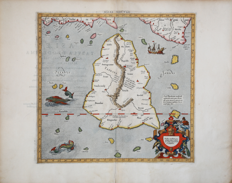
Finely colored example of Mercators's map of Taprobana, the island of Ceylon, which was sometimes confused with Sumatra on early maps.
In ancient times, Sri Lanka was known by various names, Ptolemy named it Taprobana, the Arabs Serendib, the Portuguese called it Ceilo and the British Ceylon.
Situated at the centre of numerous trade routes through the Indian Ocean, Sri Lanka was always an important trading link between east and west. As a major exporter of cinnamon, Arab and Chinese traders had frequented the island since early times and it served as an important stop for merchants on the maritime route between Asia and Europe. Much confusion existed among medieval mapmakers as to the identities of the islands of Taprobana and Sumatra which arose primarily from the descriptions in the ancient texts which stated that Taprobana was the largest island in the world. This was later contradicted by Marco Polo in his Il Milione in which he stated that it was Java Minor (Sumatra) that was in fact the largest island. As Sumatra was virtually unknown to most medieval mapmakers their primary concern was the placement of Taprobana on maps. Invariably it was incorrectly positioned off the southeast coast of Arabia but once the accounts of Marco Polo were revealed at the end of the thirteenth century, the eastern limits of the Indian Ocean were greatly expanded and the question as to the identity of the islands became more critical for mapmakers.
The Portuguese arrived on the island in 1505 and by 1518 had built a fort in Colombo, enabling them to control strategic coastal areas they had previously captured. Once Portuguese information and charts were copied, the position of Ceylon and the confusion with Sumatra was corrected.
Although, some scholars believe it is actually a depiction of the island of Sumatra. The surrounding islands are located near where Nias, Enggano and Mentawis are relative to Sumatra. The land in the upper-right corner is correct for Malaysia. Several towns and village are located (close to present cities of Lampung, Medan, Sibolga and Banda Aceh. Mountains and waterways are also located - also very near where they are found today.
Map taken from the Cl. Ptolemaei Alexandrini, Geographiae Libri Octo, first published in Cologne by Gottfried von Kempen (1578) and then reprinted by the same publisher in 1584 (Van der Krogt 1, 502) and then by Isaac Elsevier for the Petrus Bertius’ Theatrum Geographiae veteris (Leyden 1618).
Mercator's interpretation of the 28 Ptolemaic text was possibly one of the truest undertaken up until that time. He had spent 13 years researching, drawing and engraving the maps at much commercial sacrifice to himself, having seen Ortelius's Theatrum and De Jodes Speculum published, to become both technical and commercial successes. In later life he devoted himself to his edition of the maps in Ptolemy's Geographia, reproduced in his own engraving as nearly as possible in their original form.
Copperplate with fine later hand colour, in good condition.
Gerard MERCATOR (Kremer) (1512 - 1594)
|
For nearly sixty years, during the most important and exciting period in the story of modern map making, Gerard Mercator was the supreme cartographer, his name, second only to Ptolemy, synonymous with the form of map projection still in use today. Although not the inventor of this type of projection he was the first to apply it to navigational charts in such a form that compass bearings could be plotted on charts in straight lines, thereby providing seamen with a solution to an age-old problem of navigation at sea. His influence transformed land surveying and his researches and calculations led him to break away from Ptolemy's conception of the size and outline of the Continents, drastically reducing the longitudinal length of Europe and Asia and altering the shape of the Old World as visualized in the early sixteenth century.
Mercator was born in Rupelmonde in Flanders and studied in Louvain under Gemma Frisius, Dutch writer, astronomer and mathematician. He established himself there as a cartographer and instrument and globe maker, and when he was twenty-five drew and engraved his first map (of Palestine) and went on to produce a map of Flanders (1540) supervising the surveying and completing the drafting and engraving himself. The excellence of his work brought him the patronage of Charles V for whom he constructed a globe, but in spite of his favor with the Emperor he was caught up in the persecution of Lutheran protestants and charged with heresy, fortunately without serious consequences. No doubt the fear of further persecution influenced his move in 1552 to Duisburg, where he continued the production of maps, globes and instruments culminating in large-scale maps of Europe (1554), the British Isles (1564) and the famous World Map on 18 sheets drawn to his new projection (1569). All these early maps are exceedingly rare, some being known by only one copy.
In later life he devoted himself to his edition of the maps in Ptolemy's Geographia, reproduced in his own engraving as nearly as possible in their original form, and to the preparation of his 3-volume collection of maps to which, for the first time, the word 'Atlas' was applied. The word was chosen, he wrote, 'to honour the Titan, Atlas, King of Mauritania, a learned philosopher, mathematiciar, and astronomer' . The first two parts of the Atlas were published in 1585 and 1589 and the third, with the first two making a complete edition, in 1595 the year after Mercator's death.
Mercator's sons and grandsons, named above, were all cartographers and made their contributions in various ways to the great atlas. Rumold, in particular, was responsible for the complete edition in 1595. After a second complete edition in 1602, the map plates were bought in 1604 by Jodocus Hondius who, with his sons, Jodocus II and Henricus, published enlarged editions which dominated the map market for the following twenty to thirty years.
|