
| Reference: | s31415 |
| Author | Giovanni Maria CASSINI |
| Year: | 1790 |
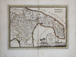
| Zone: | Basilicata/Puglia |
| Printed: | Rome |
| Measures: | 480 x 355 mm |
| Reference: | s31415 |
| Author | Giovanni Maria CASSINI |
| Year: | 1790 |
| Zone: | Basilicata/Puglia |
| Printed: | Rome |
| Measures: | 480 x 355 mm |
An uncommon map, published in the 'Nuovo Atlante Geografico Universale', with a decorative title cartouche, by Giovanni Maria Cassini, a Somasco monk. He was geographer and cartographer but he was also good at engraving architectural items and perspectives – he was one of the best disciples Giovanni Battista Piranesi had.
Moreover, Cassini was one of the last artists to engrave spheres in the XVIII century and his globes were quite famous and widespread, and realized the most important Italian Atlas of the XVIII century; his maps always bear a cartouche, extremely rich in colours and details.
Copperplate with fine later hand colour, in very good condition.
Giovanni Maria CASSINI (1745 - 1824)
|
Giovanni Maria Cassini was a fine Italian engraver, globe maker and painter. He did most of his work in Rome, and was not a member of the French Cassini family (a French Giovanni Maria Cassini was bor 120 years earlier). In 1792 Cassini published in Rome Vol. 1 of his atlas Nuovo Atlante Geografico Universale. This contained two celestial hemispheres printed in 1790, which were labeled Planisfero Celeste Settentrionale and Meridionale. Similar to Zatta's hemispheric prints, in the corners were beautiful drawings of famous observatories: Collegio Romano, Bologna, Milan and Padua in the northern plate, and Paris, Cassel, Greenwich and Copenaghen in the southern plate. Vol. 2 of this atlas was published in 1797, Vol. 3 in 1801.
|