| Reference: | S43051 |
| Author | Antonio LAFRERI |
| Year: | 1560 ca. |
| Zone: | Austria, Hungary |
| Printed: | Rome |
| Measures: | 420 x 290 mm |
| Reference: | S43051 |
| Author | Antonio LAFRERI |
| Year: | 1560 ca. |
| Zone: | Austria, Hungary |
| Printed: | Rome |
| Measures: | 420 x 290 mm |
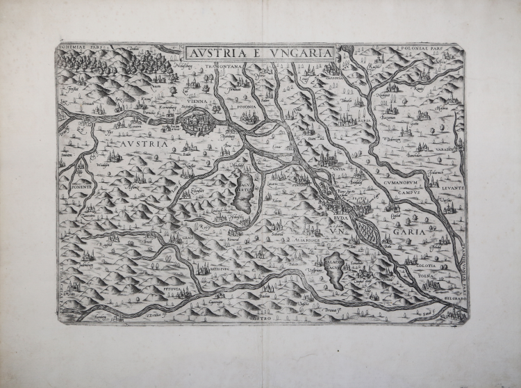
In the upper center, in an elongated cartouche below the top edge, is engraved the title: AUSTRIA E UNGARIA. Orientation in the four sides in the center, within the map, with the names of the winds: TRAMONTANA, OSTRO, LEVANTE, PONENTE, north is at the top. Map lacks graphic scale and graduation in margins.
Example of the first state of two, before the imprint of Giovanni Orlandi added at lower right.
Magnificent proof, printed on contemporary laid paper, with wide margins, in perfect condition.
The very rare work belongs to a series of Italian maps of the area - all practically the same and hardly distinguishable - that have generated great confusion in the literature. Cartografia e topografia italiana del XVI secolo distinguishes as many as 4 sixteenth-century maps, all very similar to each other. The Italian prototype would be the one engraved by Zenoi, replicated by the maps of Giovanni Francesco Camocio, Ferrando Bertelli, and this anonymous map attributed to Antonio Lafreri.
According to Almagià, Zenoi's map would be a derivation of Wolfgang Lazius' Regni Hungariae Descriptio Vera, published in Vienna in 1552-56. From a geographical point of view, the information seems instead to be derived directly from Giacomo Gastaldi's large map of the Balkans engraved by Matteo Pagano (1546) combined with others inferred from Lazàr Deàk's Tabula Hungaria (1528). The map is attributed by Szathmáry directly to Giacomo Gastaldi, and would be based on manuscript sources dating from the time of Matthias Corvinus' reign. Indeed, although published in the mid-16th century, this map would appear to depict the territory of the Kingdom of Hungary as it appeared about a century earlier under the rule of Matthias Corvinus, King of Hungary from 1458 to 1490.
“Anonymous map of Austria and Hungary, lacking date and editorial indications. The map is derived directly from the Zenoi and not from later Venetian replicas; the toponym Belgrade is also here placed north of the Danube. It is distinguished by the depiction of Lake Balaton, here with a portion left blank in the middle. This is a Roman replica of Zenoi's work, which we can attribute to the printing house of Antonio Lafreri; the French publisher's catalog includes an “Archiducato of Austria”. The plate is certainly part of the plates inherited by Claudio Duchetti. The map is in fact present in the catalog of the widow of Giacomo Gherardi, heir to Duchetti's chalcographic estate, of October 1598 (no. 330) where it is described as “Austria In ongaria reale”. However, no example signed Duchetti is known to us. The plate was then purchased by Giovanni Orlandi in 1602, who reprinted it unaltered by affixing his own name. Further issues edited by Hendrick van Schoel and Francesco de Paoli are possible, though not known” (see Cartografia e topografia italiana del XVI secolo, p. 1178).
Bibliografia
S. Bifolco, F. Ronca, Cartografia e topografia italiana del XVI secolo, tav. 1087, I/II; Alberti (2009): p. 118, n. A.26; Pagani (2012): p. 81; Szathmáry (1987): n. 41(ill. p. 109) & n. 41/6 & 41/7; Tooley (1939): n. 121.
Antonio LAFRERI (Orgelet 1512 - Roma 1577)
|
An engraver, publisher and dealer in prints and books. He moved in Rome about 1544, and began a series of joint ventures with the older Roman publisher Antonio Salamanca that continued until the latter's death in 1562. Lafrery in best known for prints showing the architecture and sculpture of ancient Rome. He commissioned a title page Speculum Romanae Magnificentiae, engraved by E. Duperac in 1573, to enable the buyer to compile his own collection from Lafrery's stock. Similarly realized collections of maps, different in the number and type of maps included with the title Geografia/Tavole moderne di geografia/de la maggior parte del mondo/di diversi autori/raccolte et messe secondo l’ordine/di Tolomeo/con i disegni di molte città et/fortezze di diverse provintie/stampate in rame con studio et diligenza/in Roma, known as Atlanti Lafrery. Besides the Speculum, Lafrery published two title pages for collections of religious subjects.
|