| Reference: | MMS38 |
| Author | Nicolas D’Abeville SANSON |
| Year: | 1669 |
| Zone: | Asia |
| Printed: | Paris |
| Measures: | 572 x 415 mm |
| Reference: | MMS38 |
| Author | Nicolas D’Abeville SANSON |
| Year: | 1669 |
| Zone: | Asia |
| Printed: | Paris |
| Measures: | 572 x 415 mm |
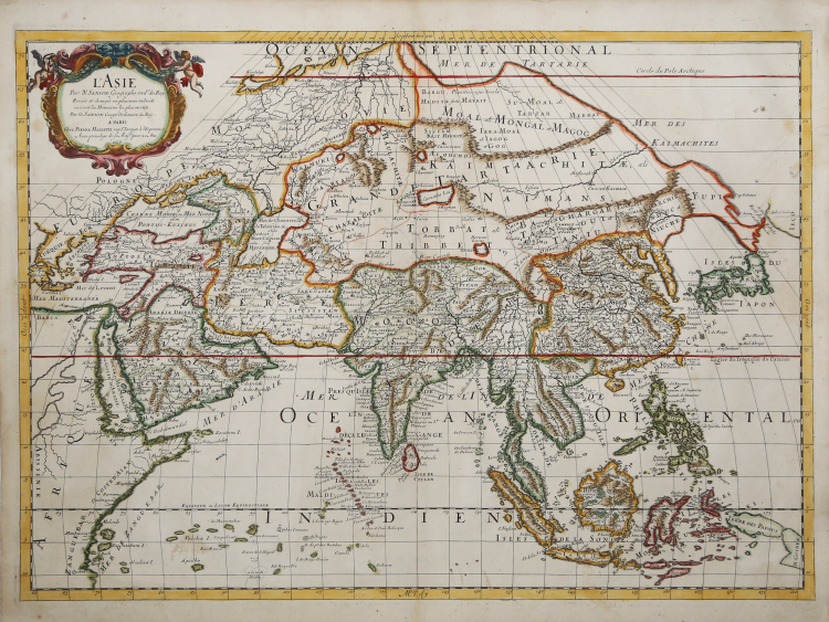
Nicolas and Guillaume Sanson's 1669 map of Asia. With an unusual projection centered on Tibet, the map depicts the entire Asian continent from Greece to the Kuril Islands and from the Arctic Ocean to New Guinea, including parts of Europe and Africa.
This is the second edition of Sanson's map of Asia, with one notable difference: Korea is depicted as an elongated peninsula, whereas in the first edition it was depicted as an island. Other aspects of East Asian geography, however, remain quite unusual. Hokkaido is illustrated as attached to the mainland as part of a vast peninsula called Yupi (Sakhalin). Separated from the mainland by the St. Vries Strait is a mysterious mainland called Ieco, a name commonly associated with Hokkaido. In this case, Sanson moved the toponymy further east and attached it to an oversized mapping of the Kuril Islands.
It is also important to note the incomplete representation of New Guinea. Another important aspect of this map's cartography is the inclusion of the mythical Lake Chiamay, here located in Southeast Asia near the border with India and Tibet. Early cartographers assumed the existence of such a lake to feed the four important river systems of Southeast Asia: the Irrawaddy, the Dharla, the Chao Phraya, and the Brahmaputra. This lake began to appear on maps of Asia as early as the 16th century and persisted until the mid-18th century. Its origins are unknown, but it may date back to a lost 16th-century geography compiled by Portuguese scholar Jao de Barros.
Map taken from "Cartes Gènerales de toutes les parties du Monde" by Sanson.
The maps were compiled by Nicolas Sanson who published his atlas in 1654, with 100 maps, and printed by Pierre Mariette; they were issued progressively from 1630.
Sanson was the most noted French cartographer in modern history. Mapmaker to Louis XIV, King of France, Sanson endowed his maps with the most recent geographical information as well as the finest and sharpest engraving of the period. His "Cartes Generales de Toutes les Parties du Monde" was the most important single product of French commercial cartography of the seventeenth century.
Copperplate, fine original colour with retouches, in good condition.
Nicolas D’Abeville SANSON (Abbeville 1600 - Parigi 1667)
|
Nicolas Sanson (December 20, 1600 - July 7, 1667) and his descendants were the most influential French cartographers of the 17th century and laid the groundwork for the Golden Age of French Cartography. Sanson was born in Picardy, but his family was of Scottish Descent. He studied with the Jesuit Fathers at Amiens. Sanson started his career as a historian where, it is said, he turned to cartography as a way to illustrate his historical studies. In the course of his research some of his fine maps came to the attention of King Louis XIII who, admiring the quality of his work, appointed Sanson Geographe Ordinaire du Roi. Sanson's duties in this coveted position included advising the king on matters of geography and compiling the royal cartographic archive. In 1644 he partnered with Pierre Mariette, an established print dealer and engraver, whose business savvy and ready capital enabled Sanson to publish an enormous quantity of maps. Sanson's corpus of some three hundred maps initiated the golden age of French mapmaking and he is considered the 'Father of French Cartography.' His work is distinguished as being the first of the 'Positivist Cartographers,' a primarily French school of cartography that valued scientific observation over historical cartographic conventions. The practice result of the is less embellishment of geographical imagery, as was common in the Dutch Golden Age maps of the 16th century, in favor of conventionalized cartographic representational modes. Sanson is most admired for his construction of the magnificent atlas Cartes Generales de Toutes les Parties du Monde. Sanson's maps of North America, Amerique Septentrionale (1650), Le Nouveau Mexique et La Floride (1656), and La Canada ou Nouvelle France (1656) are exceptionally notable for their important contributions to the cartographic perceptions of the New World. Both maps utilize the discoveries of important French missionaries and are among the first published maps to show the Great Lakes in recognizable form. Sanson was also an active proponent of the insular California theory, wherein it was speculated that California was an island rather than a peninsula. After his death, Sanson's maps were frequently republished, without updates, by his sons, Guillaume (1633 - 1703) and Adrien Sanson (1639 - 1718). Even so, Sanson's true cartographic legacy as a 'positivist geographer' was carried on by others, including Alexis-Hubert Jaillot, Guillaume De L'Isle, Gilles Robert de Vaugondy, and Pierre Duval.
|