| Reference: | S299570 |
| Author | Johannes VAN KEULEN |
| Year: | 1683 ca. |
| Zone: | Malta |
| Printed: | Amsterdam |
| Measures: | 497 x 290 mm |
| Reference: | S299570 |
| Author | Johannes VAN KEULEN |
| Year: | 1683 ca. |
| Zone: | Malta |
| Printed: | Amsterdam |
| Measures: | 497 x 290 mm |
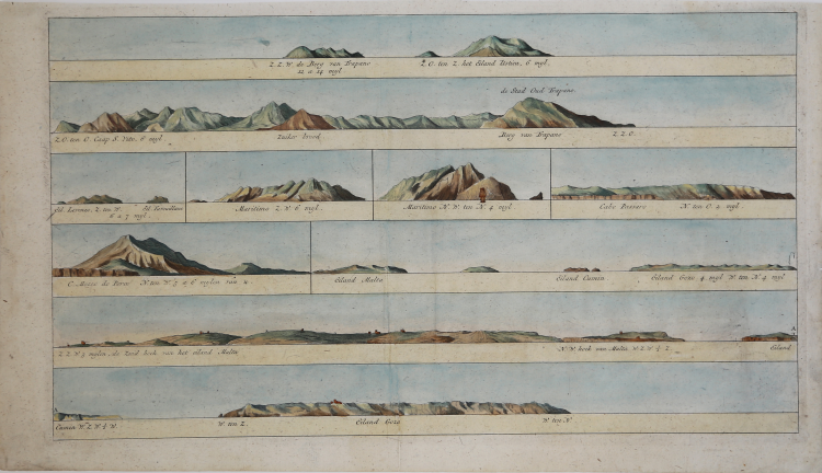
Coastlines relating to the Sicilian Channel taken from the late 1781 edition of Zee-Fakkel by the Van Keulen family. The table depicts Trapani, Ustica, San Vito lo Capo, the Egadi Islands, Cape Passaro, and the Maltese archipelago. The van Keulen Publishing House was founded around 1678 by the founder Johannes, who was succeeded in 1695 by his son Gerard, versed in nautical disciplines and skilled engraver, who gave the company the cartographic specialization that made it famous in Holland and Europe for two centuries to follow.
The editorial production included a large portfolio of manuscript loose charts, a nautical atlas called Le Grand Nouvel Atlas de la Mer and the monumental De Nieuwe Groote Lichtende Zee-Fakkel, or a pilot book of the seas of the world published between 1681 and 1684 in five volumes in folio, to which - in 1753 - was added a sixth for navigation along the coasts of Asia.
According to an editorial formulation consolidated since the Spieghel der Zeewaerdt of L. J. Waghenaer, the first volume describes the northern seas from Holland to the Hudson Strait, while the second volume is devoted to navigation from the North Sea to the continental European coasts to the Cape Verde Islands. The third volume describes the Mediterranean, which was particularly important as a “crossroads” of trade between East and West. The fourth volume covers the West Indies and the eastern coasts of North America, while the fifth contains maps of West Africa to the Cape of Good Hope and eleven maps of Brazil, as well as some maps of the Far East that prelude to the compilation of the sixth volume.
The Asian coasts were, in fact, of pre-eminent interest to Holland, which had founded a commercial empire, and then the cards of those regions remained for a long time manuscript, so that it was prevented from spreading outside the fleet of the VOC, until 1753, when by then were already several decades in circulation nautical atlases published by the British and French.
The Nieuwe Groote Lichtende Zee-Fakkel, which included nautical instructions, general and detailed charts, plans of ports and coastal views, was translated into several languages and printed in several editions.
The third book, dedicated to the Mediterranean, had an Italian edition, published in 1695 with the title Della nuova grande illuminante face del mare and reprinted in 1705. As the extensor of the text is N. J. Vooght, while the Italian translation is the Paduan Moses Giron. Several papers bear dates subsequent to the publication of the pilot book, because while the text did not require updates, the cards were replaced over time as needed.
Copperplate, finely colored by hand, in excellent condition.
Johannes VAN KEULEN (1654 - 1715)
|
As we have noted in other biographies in this chapter, the Dutch produced a remarkable number of enterprising and prolific map and chart makers but not even the Blaeu and Jansson establishments could rival the vigour of the van Keulen family whose business was founded in 1680 and continued under their name until 1823 and in other names until 1885 when it was finally wound up and the stock dispersed at auction.
Throughout the history of the family, the widows of several of the van Keulens played a major part, after their husbands' deaths, in maintaining the continuity of the business.
The firm was founded by Johannes van Keulen who was registered as a bookseller in Amsterdam in 1678. In 1680 he published the first part of his Zee Atlas which, over the years, was expanded to 5 volumes and continued in one form or another until 1734. More ambitious and with a far longer and more complicated life was his book of sea charts, the Zee-Fakkel, published in 1681-82 which was still being printed round the year 1800. A major influence in the development of the firm was the acquisition in 1693 of the stock of a rival map publisher, Hendrik Doncker.
Although the firm was founded by Johannes van Keulen, he was primarily a publisher; it was his son, Gerard, a talented engraver, mathematician, Hydrographer to the East India Company, who became the mainspring of the business which not only published charts but also books on every aspect of geography, navigation and nautical matters.
|