| Reference: | S41698 |
| Author | Jacques Nicolas BELLIN |
| Year: | 1756 |
| Zone: | Flags of maritime powers and nations in the whole world |
| Printed: | Paris |
| Measures: | 900 x 610 mm |
| Reference: | S41698 |
| Author | Jacques Nicolas BELLIN |
| Year: | 1756 |
| Zone: | Flags of maritime powers and nations in the whole world |
| Printed: | Paris |
| Measures: | 900 x 610 mm |
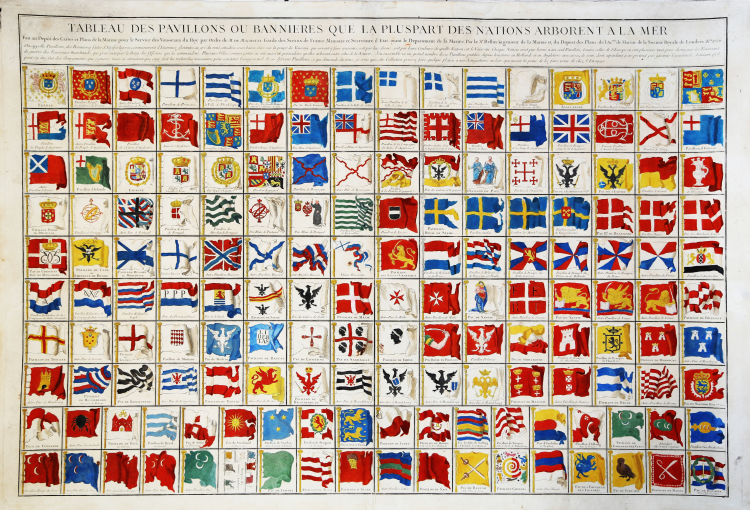
Tableau des pavillons ou Bannières que la pluspart des nations arborent à la mer fait au dépot des Cartes et plans de la Marine pour le service des Vaisseaux du Roy par ordre de M. de Machault, garde des sceaux de France, Ministre et secrétaire d'état ayant le Département de la Marine, par le s.r Bellin, ingénieur de la marine, et du dépos des plans, de l'Ac.mie de Marine de la Société royale de Londres, etc. 1756.
Fine large engraved plate, with 180 different National and Maritime Flags, which appeared in Bellin's Hydrographie Francois.
The map includes a remarkable array of nations and states, including a number of Asian Countries (8 Turkish Flags, plus flags for Bantam, China, Tartaria, and Batavia) and several African nations. The most historically significant element is its illustration of the ephemeral New England Globe Flag, on of the earliest examples of American flag.
Copperplate with fine original hand colour - washed and refreshed - with margins, very good condition.
Jacques Nicolas BELLIN (1703 - 1772)
|
Jacques-Nicolas Bellin (1703 - 1772) was one of the most important cartographers of the 18th century.
With a career spanning some 50 years, Bellin is best understood as transitional mapmaker spanning the gap
between 18th and early 19th century cartographic styles. His long career as Hydrographer and Ingénieur
Hydrographe at the French Dépôt des cartes et plans de la Marine resulted in hundreds of high quality
nautical charts of practically everywhere in the world. Bellin's work focuses on function and accuracy
tending in the process to be less decorative than the earlier 17th and 18th century cartographic work. In
addition to numerous maps and charts published during his lifetime, many of Bellin's maps were updated
(or not) and published posthumously. He was succeeded as Ingénieur Hydrographe by his student, also a prolific and influential cartographer, Rigobert Bonne.
|